As per a survey done in the year 2019 It is expected that in the next 10 years, the use of drones in construction domain will register a major growth and will play a leading role in new buildings that would be constructed. According to a recent industry report, India is one of the fastest growing markets for using UAVs and by 2021, the Indian UAV market is expected to reach $885.7 million. This sector is the fastest-growing adopter of commercial drones, and is likely to require 2.5 lakh people with UAV (unmanned aerial vehicle) operating skills in the coming years. We are talking of highways, roads, bridges and housing will take the lead in the usage of drones, and RAS is here to help this segment of the industry to grow to new heights.
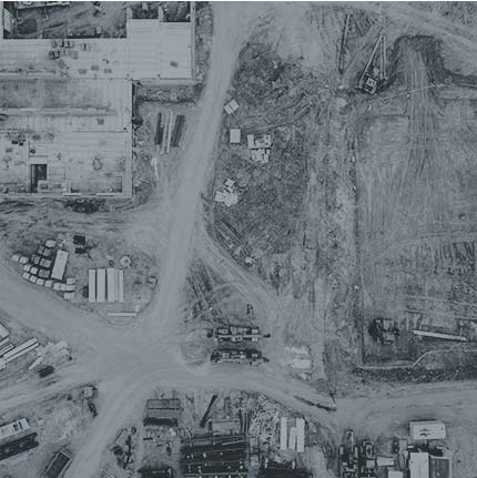
Construction Sector The Traditional Way
▪️On a construction project, new hazards are a recurrent feature ▪️Safety of man and machine are always an irritant ▪️A lot of time goes in surveys and measurements which in some cases can go on for months ▪️A lot of time goes in surveys and measurements which in some cases can go on for months ▪️Data capture may not be very accurate and many times needs to be re-evaluated ▪️Post processing of data is also a long and tedious task ▪️Operating costs are very high ▪️A lot of manpower is deployed which increases costs ▪️Weather plays a major role in the delay especially during a natural calamity or excessive rains
Benefits of Using Drones
- UAVs and drones can be deployed to conduct safer, faster and more accurate inspections instead
- Safety of people is no longer an issue as physical inspections are almost removed
- Drones Equipped with cameras, GPS units, thermal and infrared sensors
- Drones can capture key data on the building site with precision
- Monitoring and tracking is very easy and a live feed can be given to anyone across the globe
- Thermal imaging can make inspection at night easy as well as being used to detect cracks or leaks
- Saves a lot of time and money when it comes to surveys as hundreds of acres of land can be mapped or surveyed in minutes